Aerial photography stopped being a luxury for real estate marketing several years ago. Today, buyers expect to see how a property sits in its lot and its neighborhood before they ever click through to the next listing. A well-shot drone frame answers questions that ground-level photos cannot — the size of the garden, the distance to the water, the orientation of the building, the texture of the surrounding street. The catch is that drone work sits at the intersection of three skills that are not usually held by the same person: licensed flight, architectural framing, and post-production. This guide walks through how to put those three together for property work in 2026, and where AI tooling shortens the slowest part of the chain.

Why aerial frames earn the click on listings buyers screen quickly
Online listings live or die on the first three thumbnails. A strong ground-level hero shot answers what is this property. A drone frame answers a different question entirely: where is it, and what surrounds it. For larger lots, waterfront homes, rural property, gated communities, and commercial sites, that context is often the single most decision-relevant piece of visual information in the gallery.
For smaller urban properties, the calculation is different. A 60 m² apartment in a dense city core does not gain much from an aerial — the value is in the interior. The honest rule of thumb is that drone work helps most when the surroundings are part of what is being sold. If the answer to "would a buyer care what the block looks like from above" is yes, the aerial earns its place in the gallery.
The legal layer: Part 107, EASA, and insurance
Most jurisdictions treat commercial drone work — anything you are paid for, including a listing shoot — under a stricter rule set than recreational flight. In the United States, that means a remote pilot certificate under FAA Part 107. In the EU and UK, the relevant framework is the EASA Open Category with appropriate subcategory permissions. National civil aviation authorities — Turkey's SHGM, Australia's CASA, Canada's Transport Canada — each maintain their own registration and flight authorization requirements.
The practical implications go beyond the test itself. Airspace restrictions near airports, heliports, military zones, and certain stadiums require either an unlock through services like LAANC in the US or a direct authorization request. Densely populated overflight, night operation, and beyond-visual-line-of-sight all add further requirements in most regimes. And third-party liability insurance — usually a separate policy or rider — is the protection that matters if something goes wrong over a client's property. Agents commissioning drone work should ask the operator to confirm certification and coverage in writing before the shoot.
Choosing the right drone for property work
For real estate, the sweet spot is a drone light enough to fly under the simplest regulatory category, with a sensor and lens system good enough to produce portal-quality stills and 4K video. That combination has become significantly more achievable at the consumer end of the market over the last two years.
Sub-250-gram models — the DJI Mini 4 Pro is the current reference point — fall into the lightest weight class under both FAA and EASA regulations, which simplifies registration and reduces overflight restrictions in many jurisdictions. They shoot vertically, which matters if you plan to repurpose footage for short-form social. For larger commercial listings, multi-lens systems like the DJI Mavic 3 Pro give optical reach for architectural detail without flying closer than necessary. Autel's EVO Lite+ is a credible alternative with strong low-light behavior. Whichever you pick, confirm the weight class against your country's current rules — the thresholds do shift.
Framing that actually sells: hero, top-down, context
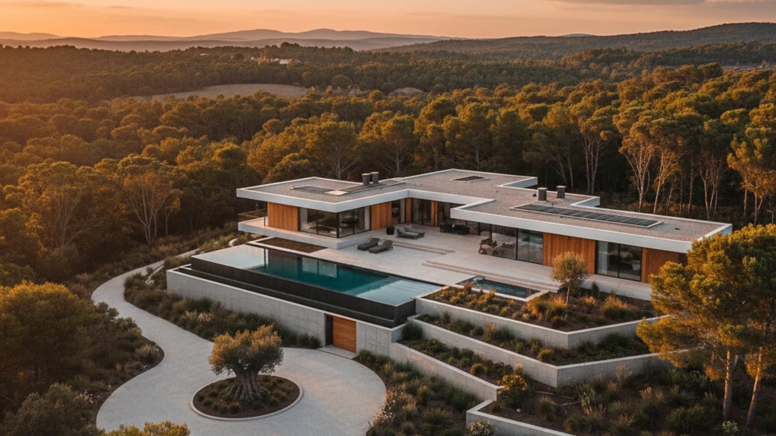
The most common drone-photography mistake on real estate listings is flying too high. A 120-metre ceiling shot tells you nothing useful about the property. A strong aerial gallery is usually built around three frame types and not much else.
The hero aerial sits ten to fifteen metres up at roughly eye-level for a treetop, facing the property's strongest elevation. It captures the building plus its immediate setting — driveway, front yard, garage — in one composition. The top-down sits much higher and looks straight down to show lot boundaries, garden layout, and the relationship between buildings. It is most useful when the lot itself is a selling point. The context wide pulls back to show what is around — a beach, a park, a vineyard, a city skyline — so the buyer understands the lifestyle attached to the address.
Sequencing matters as much as framing. The same gallery logic from our listing photo optimization guide applies here: the aerial that earns the click is usually the second or third frame, after a strong ground-level hero. Lead with the most legible image, then use the aerial to expand the story.
Cleaning up aerials with AI: skies, noise, distractions
The single biggest constraint on drone real estate shoots is not gear — it is weather. Overcast skies, grey midday light, and unflattering haze can make even a well-framed aerial look flat. Historically the fix was to wait for a better day, which is rarely an option on a listing schedule.
AI-driven sky replacement and exposure recovery have closed most of that gap. AI photo enhancement can lift exposure on a flatly-lit aerial, recover detail in the shadow side of a building, and rebalance colour so the property reads warm rather than concrete-grey. Exterior retouching handles the next layer — removing a neighbour's parked truck from the frame, cleaning construction debris from a garden, or replacing a dull overcast sky with a believable blue one. The rule on sky replacement is the same as for ground-level twilight conversion covered in our day-to-dusk guide: the replacement should reflect a sky the property actually sees, not an aspirational one.
Turning drone footage into reels, slideshows, and tour videos
Raw 4K drone footage is rarely usable as-is for a listing. The pacing is too slow for a portal page and far too slow for social. The fastest path to a publishable asset is to treat the aerial as raw material — pick the three or four strongest moments, then sequence them with ground-level footage and stills.
Video slideshows handle the long-form version for listing pages and email follow-up. Short-form reels handle the vertical cut for Instagram and TikTok, where aerial footage performs disproportionately well — a slow push over a coastline or rooftop is almost made for the format. If you want a presenter narrating the tour, AI presenter and AI voiceover tools can layer the script onto the visuals without booking a videographer or a talent shoot. The same workflow we walk through in making a real estate video from photos applies, with drone clips slotting in as the opening and bridge sequences.
Honest aerials: where the edit line sits
Aerials are unusually trust-sensitive because they show context buyers cannot easily verify from the ground. A sky replacement that turns a real grey day into a real-looking blue day is widely accepted across the industry — it is closer to the colour correction every professional photographer already does. The line shifts when the edit changes what the property actually is.
Edits to avoid: removing a permanent structure (a transmission tower, a busy road, a neighbouring building) that materially affects how the property is experienced; recolouring brown lawns to green outside of what the season would actually show; suggesting amenities that do not exist by composite or paint-over. The NAR guidance on AI-altered listing photos is a useful baseline — if an edit could plausibly change a buyer's offer, it crosses the disclosure line. For aerials, the safest practice is to disclose meaningful sky replacement and any object removal in the listing description.
Sources and further reading
Frequently asked questions
Do I need a commercial licence to use drone photos in my listings?+
In most jurisdictions, yes. If you are paid for the work — directly or indirectly through a listing — civil aviation regulators usually treat it as commercial. In the US that is the FAA Part 107 certificate; in the EU and UK it is an EASA Open Category authorization with the relevant subcategory; in Turkey it is an SHGM operator registration. The agent does not need the licence personally, but the pilot does, and you should confirm coverage and certification in writing before commissioning a shoot.
Which drone is best for real estate photography in 2026?+
For most agents and small studios, the DJI Mini 4 Pro is the practical default — under 250 grams, vertical-shooting, and good enough for both portal stills and short-form video. For larger commercial work or high-end residential where architectural detail matters, the DJI Mavic 3 Pro adds optical reach. Autel's EVO Lite+ is a credible alternative if you want to avoid the DJI ecosystem.
How many aerial shots should a listing actually include?+
Usually two or three is enough. One hero aerial as the second or third frame in the gallery, one top-down if the lot is a selling point, and one context wide if the surroundings matter. Galleries that lean too heavily on aerials tend to underperform — buyers still want to see the interior.
Is AI sky replacement on a drone photo considered misleading?+
Replacing a flat grey sky with a clear blue one is generally accepted as part of normal photo editing, the same way colour correction is. The line shifts when the edit changes the property itself — removing a power line, hiding a neighbouring building, or implying a view that does not exist. NAR's guidance is that any edit that could materially change a buyer's offer should be disclosed.
Can I shoot drone footage in bad weather and fix it later?+
To a point, yes. AI enhancement can recover a flat or grey-skied shoot remarkably well. What it cannot recover is wind-induced softness on a video frame, rain droplets on the lens, or footage shot at an angle the regulations did not permit. If wind is gusting above your drone's rated tolerance — typically 10–12 m/s for consumer airframes — it is safer to reschedule than to rely on post.
Topics covered in this guide
drone photography for real estate, real estate aerial photography, drone real estate guide, FAA Part 107 real estate, drone listing photos.